Cantabria by Bike
The
Way of Saint James in Cantabria
GPS
Tracks
By: Michael
González Harbour
Contents
Introduction
The North Way of Saint James, at its transit through Cantabria,
represents a great opportunity for all, pilgrims, residents and
visitors, to visit the coastal strip of Cantabria with its villages,
paths, and people. The track is mainly through secondary roads and
paths that let us approach small villages, hermitages, and
unforgettable corners, many of them unknown even to those of us who
live
in Cantabria.
The tracks are all cyclable, except for a small section in the Stage
between Laredo an Noja, where we suggest a variant for bicycles. It is
difficult to get lost, because the track is very well signed with
yellow arrows.
This page does not try to be a guide for pilgrims, because many can be
found in bookshops and in the net (see for example Mundicamino, and its section on
The North Way). We just want to publish the itinerary, the profiles,
and the GPS tracks.
The distribution in stages follows the classic stages of some guides.
They may be a bit short for bicycles, so it may be advisable to join
two or three of them to make on the same day. We hope that you enjoy
them.
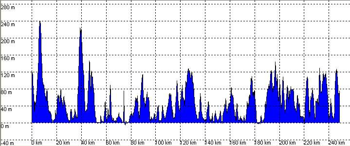
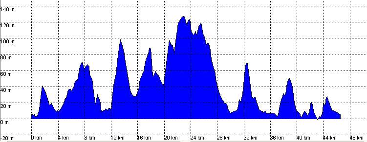
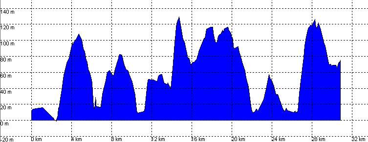
The Way of Saint James
in Cantabria: Complete track
Basic
Data
Kilometers
|
251
|
Cumulative ascent
|
3855
|
Cumulative descent
|
3895
|
Maximum height: meters
|
239
|
Difficulty
|
Low
|
Recommended period
|
All year round
|
Map

Profile
Downloads
To open the route in Google Earth click on the 'KMZ' link and select
'Open with Goole Earth' (requires prior installation of Google Earth).
botón
To download a route, right-click on the link and select 'save link as'
or a similar option.
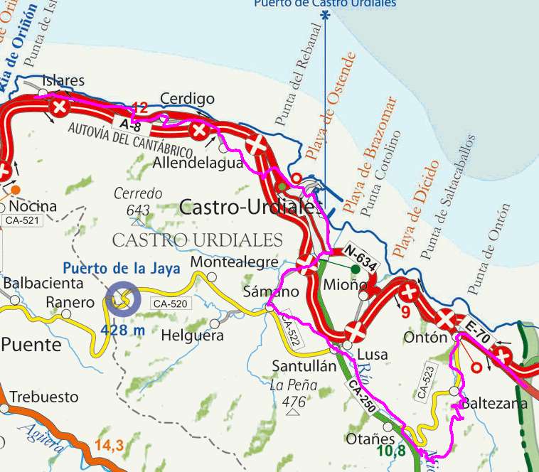
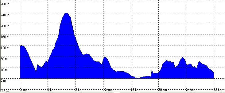
Stage 1: Ontón - Islares
Basic
Data
Kilometers
|
28
|
Cumulative ascent
|
430
|
Cumulative descent
|
526
|
Maximum height: meters
|
239
|
Difficulty
|
Low
|
Recommended period
|
All year round
|
Map
Profile
Downloads
To open the route in Google Earth click on the 'KMZ' link and select
'Open with Goole Earth' (requires prior installation of Google Earth).
botón
To download a route, right-click on the link and select 'save link as'
or a similar option.
Stage 2: Islares - Laredo
Basic
Data
Kilometers
|
24
|
Cumulative ascent
|
488
|
Cumulative descent
|
496
|
Maximum height: meters
|
223
|
Difficulty
|
Low
|
Recommended period
|
All year round
|
Map
Profile
Downloads
To open the route in Google Earth click on the 'KMZ' link and select
'Open with Goole Earth' (requires prior installation of Google Earth).
botón
To download a route, right-click on the link and select 'save link as'
or a similar option.
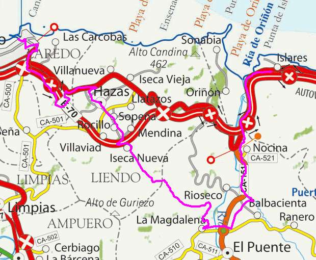
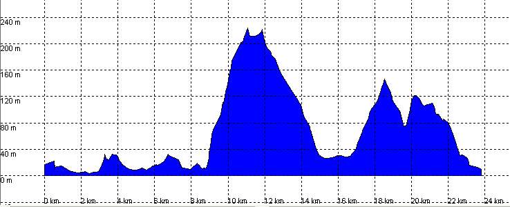
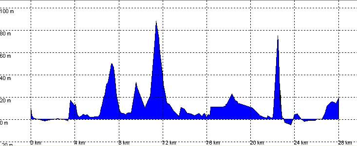
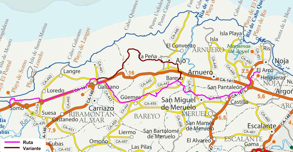
Stage 3: Laredo - Noja
Basic
Data
Kilometers
|
28
|
Cumulative ascent
|
340
|
Cumulative descent
|
331
|
Maximum height: meters
|
88
|
Difficulty
|
Low
|
Recommended period
|
All year round
|
Map
The variant is recommended for bicycles, since the track between the
beaches of Berria and Noja through the cliffs of "el Brusco" is not
cyclable.
Profile
Downloads
To open the route in Google Earth click on the 'KMZ' link and select
'Open with Goole Earth' (requires prior installation of Google Earth).
botón
To download a route, right-click on the link and select 'save link as'
or a similar option.
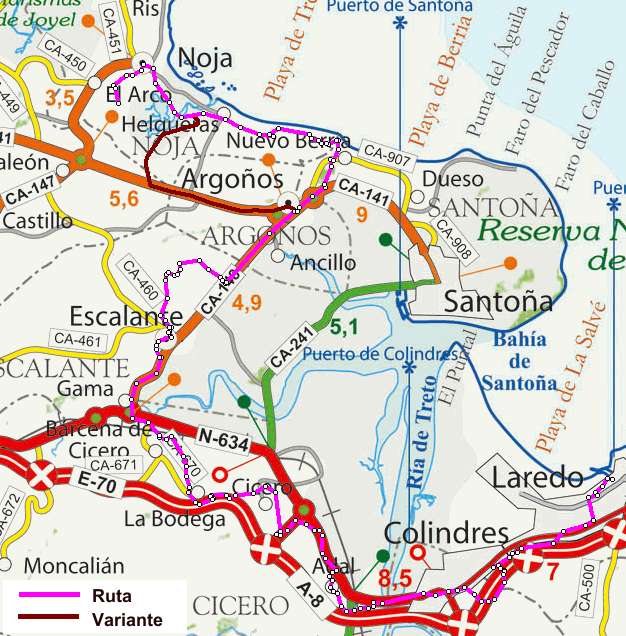
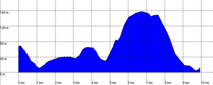
Stage 4: Noja - Santander
Basic
Data
Kilometers
|
24
|
Cumulative ascent
|
315
|
Cumulative descent
|
329
|
Maximum height: meters
|
114
|
Difficulty
|
Low
|
Recommended period
|
All year round
|
Map
It is possible to cross frnom Somo to Santander using a passenger
ferry, or following the optional stage mentioned below. You ca carry
the bicycles in the ferry, after buying a special ticket.
The variant is a path closer to the coast, with a little more climbing.
Both the main route and the variant are completely cyclable.
Profile
Main Route:
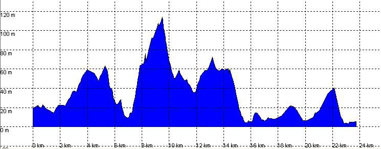
Variant:
Downloads
To open the route in Google Earth click on the 'KMZ' link and select
'Open with Goole Earth' (requires prior installation of Google Earth).
botón
To download a route, right-click on the link and select 'save link as'
or a similar option.
Stage Opcional: Ronda
de la Bahía de Santander
Basic
Data
Kilometers
|
47
|
Cumulative ascent
|
596
|
Cumulative descent
|
598
|
Maximum height: meters
|
127
|
Difficulty
|
Low
|
Recommended period
|
All year round
|
Map
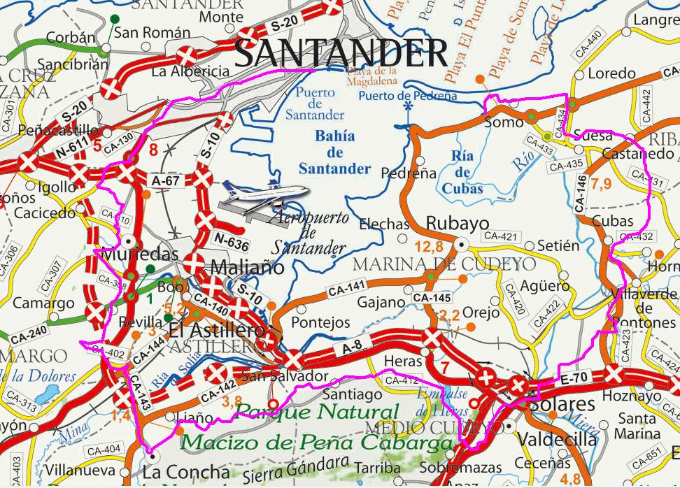
Profile
Downloads
To open the route in Google Earth click on the 'KMZ' link and select
'Open with Goole Earth' (requires prior installation of Google Earth).
botón
To download a route, right-click on the link and select 'save link as'
or a similar option.
Stage 5: Santander -
Santillana del Mar
Basic
Data
Kilometers
|
45
|
Cumulative ascent
|
619
|
Cumulative descent
|
438
|
Maximum height: meters
|
123
|
Difficulty
|
Low
|
Recommended period
|
All year round
|
Map
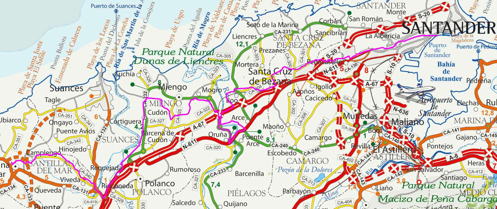
Profile
Downloads
To open the route in Google Earth click on the 'KMZ' link and select
'Open with Goole Earth' (requires prior installation of Google Earth).
botón
To download a route, right-click on the link and select 'save link as'
or a similar option.
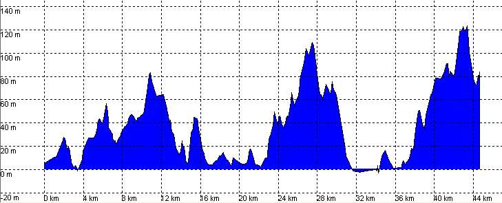
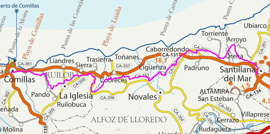
Stage 6: Santillana del Mar
- Comillas
Basic
Data
Kilometers
|
22
|
Cumulative ascent
|
413
|
Cumulative descent
|
487
|
Maximum height: meters
|
144
|
Difficulty
|
Low
|
Recommended period
|
All year round
|
Map
Profile
Downloads
To open the route in Google Earth click on the 'KMZ' link and select
'Open with Goole Earth' (requires prior installation of Google Earth).
botón
To download a route, right-click on the link and select 'save link as'
or a similar option.
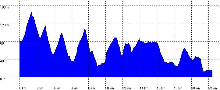
Stage 7: Comillas - Unquera
Basic
Data
Kilometers
|
31
|
Cumulative ascent
|
615
|
Cumulative descent
|
552
|
Maximum height: meters
|
129
|
Difficulty
|
Low
|
Recommended period
|
All year round
|
Map
Profile
Downloads
To open the route in Google Earth click on the 'KMZ' link and select
'Open with Goole Earth' (requires prior installation of Google Earth).
To download a route, right-click on the link and select 'save link as'
or a similar option.
Instructions
See the instructions and disclaimer, as well as other routes, in the main page.